Washington County Durham
HOME WHAT'S WHERE MORE BRIDGES MORE BLUE PLAQUES
Memories of Washington
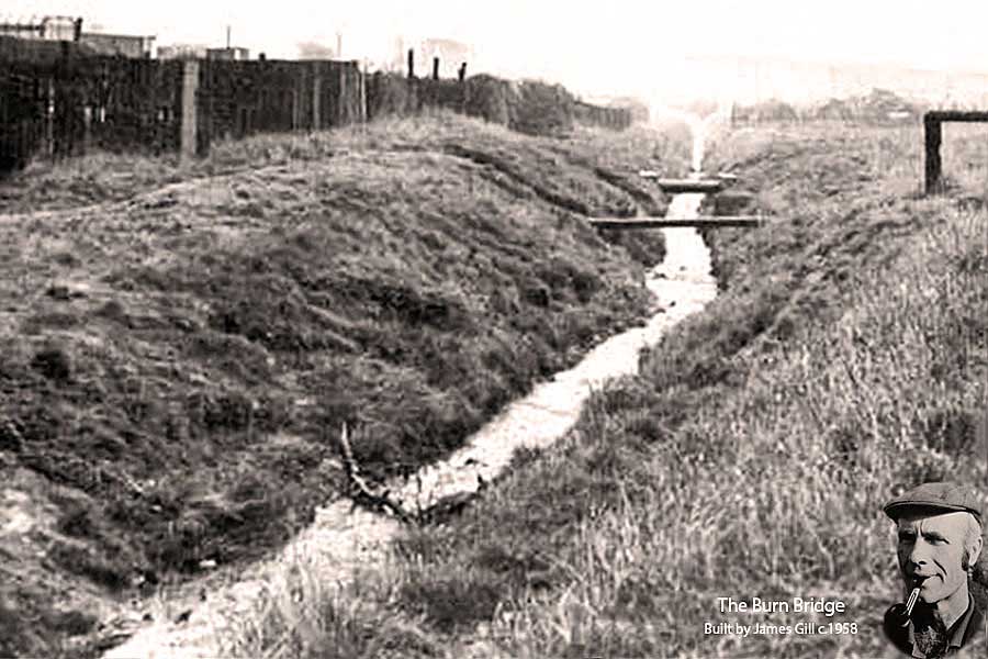
The Bridge over The Burn
The Bridge over 'The Burn'
High Row to Don Gardens
THEN
The Bridge, and two Steel Pipes crossing The Burn, one hidden behind the other.
A popular shortcut between High Row and Don Gardens / Usworth.
Council Workers' Hut? 10 to 20 metres off-picture, left.
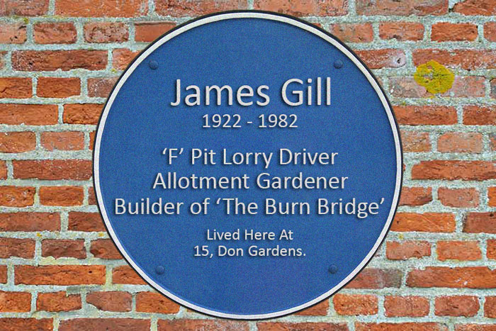
The Bridge over The Burn was built (circa 1958) by 'F' Pit Lorry Driver, James Gill (1922-1982).
It comprised two railway sleepers on foundations made from large wooden chocks.
I suspect that this material was probably 'courtesy' of the N.C.B.
He cut a path into the north bank, and his bridge
immediately became the route of choice
from High Row to Don Gardens.
( Dad's Allotment: top-left. )
Who Remembers Jumpin' Diggers? And Gettin' Wet!
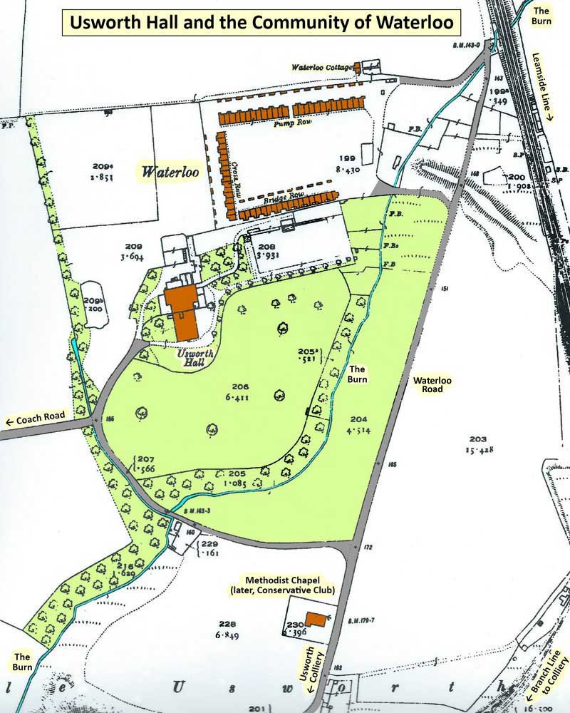
See Usworth Hall Map below.
[ A Digger: A leap from one side of The Burn to the other. ]
• • ◊ • •
Awarded by This Website on behalf of the Scores of People who crossed The Burn Bridge every day.
• • ◊ • •
Look what happened to THE BURN!
Inkerman Road
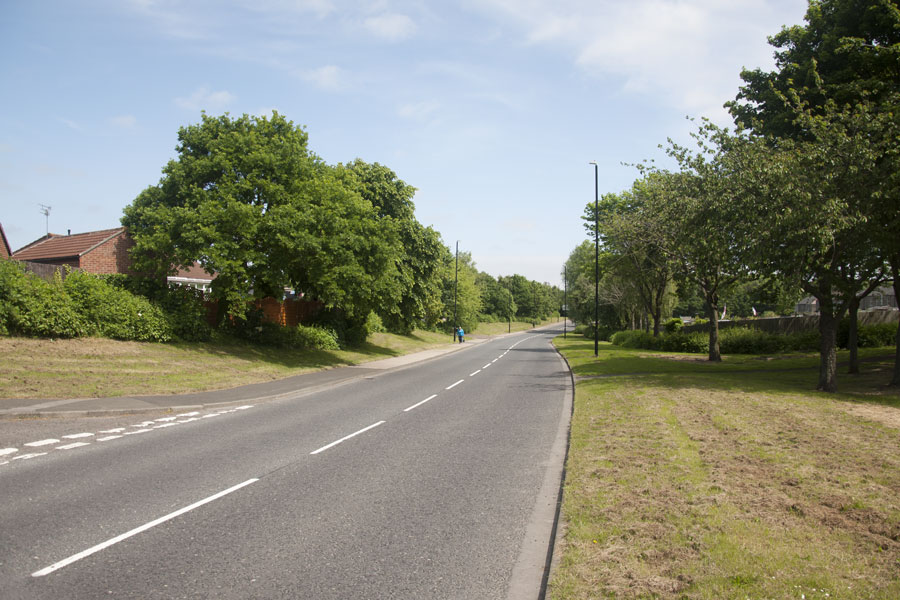
NOW
The junction on the left leads to the last house in High Row. It was a dirt track in the 1960s.
Who remembers the Council Workers' Hut that stood just around the corner?
The allotments on the right are closer to the former bridge site.
The Bridge? Where the path changes colour.
[ Photo: J.G. 5th June 2018 ]
• • ◊ • •
Most People called it THE BURN. Some People called it THE DON.
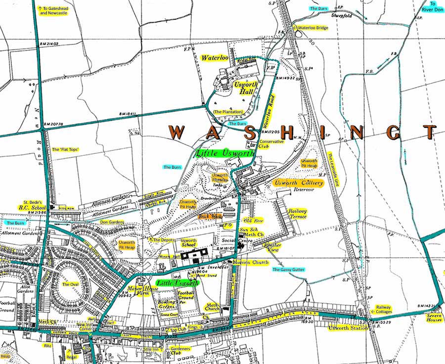
MAP: 1951
THE BURN flowed east from a tunnel under Heworth Road, passing between
High Row and the Children's Playground (opposite British Legion).
It then passed between the allotments and Don Gardens,
under James Gill's 'railway sleeper' bridge,
and under the minor road leading to
Quarry Row and Single Row.
Continuing along the south side of Quarry Row, it was joined by a small stream
eminating from Usworth Pit Heap before turning left, passing under the
bridge at the far end of Quarry Row / Single Row. It continued
north-east, along the west side of Usworth Pit Heap, before
going under the road bridge and into the grounds of
Usworth Hall. The Burn then passed through the
community of Waterloo before passing under
the Leamside Railway at Waterloo Bridge
and continuing to join the River Don.
This Map Settles The Argument
Extract from O.S. Map, One Inch, 7th Series, 1955-61.
* THE BURN ( Blue Dots ) is a Tributary of The RIVER DON. It is NOT The River Don! *
Our older visitors will almost certainly have crossed the River Don on their way to the seaside!
The No.62 Bus to South Shields crossed the River Don as it approached Boldon Colliery.
The River Don passes under the 'yellow road', down the bank from the 'red road'.
See top-right-hand corner of map.
Can you trace the No.62 Bus Route from New Washington Bus Station, past the Three Horse Shoes and through Boldon Colliery?
[ Don't forget: It passed the off-picture N.C.B. Boldon Colliery twice, and crossed the Consett / Tyne Dock Railway five times! ]
• • ◊ • •
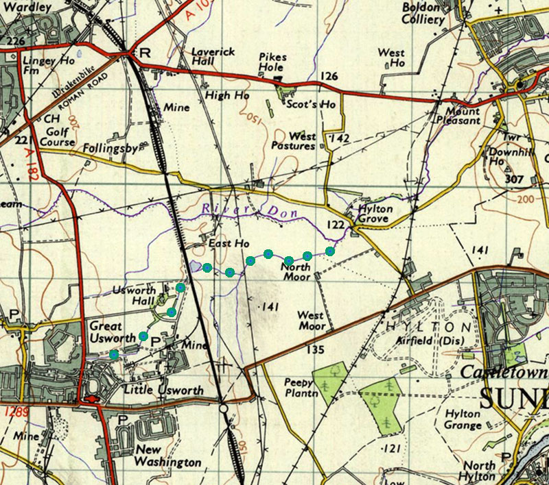
HEWORTH ROAD, 1955
This is where The Burn passed under Heworth Road i.e. between the side road to Tyne Gardens, and High Row.
The side road passed the Royal British Legion, on the right, and a Children's Play Park on the left.
The Burn flowed between the Play Park and High Row. Note Saint Bede's School.
Who remembers the nearby Old Ladies
Fish & Chip Shop?
They cooked with Oil not Fat. Delicious!
[ Pass The Legion, then 1st right. ]
• • ◊ • •
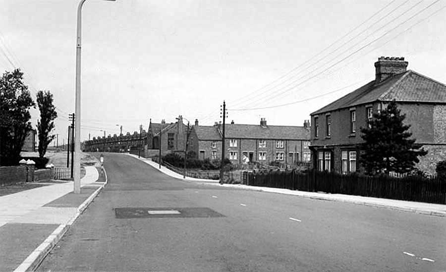
SINGLE ROW and QUARRY ROW, 1955
Note the Bridge over The Burn just before the track heading up the Pit Heap - to Usworth Colliery.
The Burn flows from right to left as it makes its way to the Grounds of Usworth Hall.
• • ◊ • •
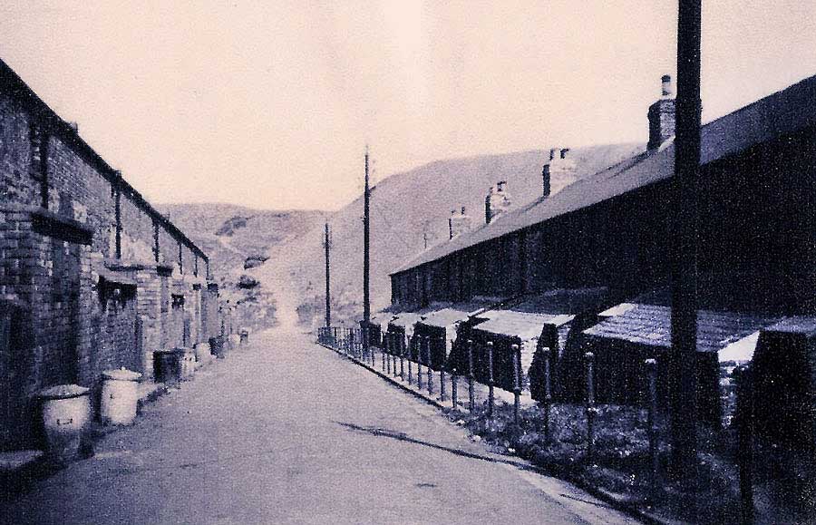
THE BURN running from DON GARDENS to SINGLE ROW
( View from the Top of Usworth Pit Heap )
Note the right-angled turn before The Burn skirts the Pit Heap en-route to Usworth Hall.
( Also visible: 1½ 'F' Pit Heaps, Don Gardens and Saint Bede's School. )
• • ◊ • •
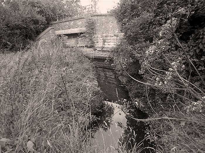
THE NEXT BRIDGE DOWNSTREAM

Bridge over The Burn on the road connecting Usworth Hall and Usworth Colliery.
Usworth Hall Grounds are behind the trees. See Map below.
( Photo: Laura Simpson. I've never liked facing a camera! Jim )
Usworth Hall Grounds, inside the encircling roads, were known to the locals as The Plantation / Plant'on.
Young lads would jump 'diggers', over The Burn, all the way from Don Gardens to Waterloo.
Some jumps were easy; some jumps were tricky; somebody always got wet.
We also had to dodge pit ponies as they galloped through
The Plantation's trees!
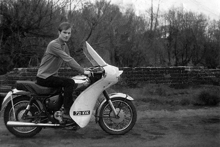
Yours Truly riding my Royal Enfield 350cc Bullet.
Leaving Waterloo across the Bridge from
Bridge Row to Waterloo Road.
No helmet req'd!
Finally: The Burn continued under a small road bridge
before passing under the Leamside Railway
en route to the River Don.
See above Map.
THE LEAMSIDE RAILWAY LINE crossing THE BURN at WATERLOO

Follingsby Colliery & Newcastle Central Station, left - Usworth Colliery & London, right
• • ◊ • •
1. THE BURN is a tributary of the River Don.
2. The RIVER DON is a tributary of the River Tyne. Its source is near Springwell and it ends its journey at Jarrow.